
 Every day, thousands of Americans wake up and exclaim "Let's start a business!" Every day half the people who started a business fail. Within five years of the starting point, well under 5% still consider themselves in business. Part of the problem is understanding your business to begin with. To say that you know your intended business well and don't need a formal business plan is just another way to court disaster. It's almost inevitable.
Vermont Flower Farm started in Shelburne, Vermont in the early 1980s and made the move to Marshfield in 1989. By 1992 the original Vermont Herb & Flower Farm was reorganized with a reduced product line, no herbs, and a different marketing strategy. Three years ago a web site replaced a hand produced 44 page catalog. The overall strategy was meeting expectations close enough to consider the next step which was relocation to a more visible, higher traffic location.
The journey from Shelburne to Marshfield was a long one, with lots of hard work, some failures, and some interruptions. As we continued to grow our flower business, I thought seriously of writing a book to help others walk more easily the distance we had covered. I may still write that book some day. I have found one which satisfies much of what I wanted to say, I like the style, and the author is known as a successful person. That person is Tony Avent and his book, So You Want To Start A Nursery was published by Timber Press in 2003. If you're even remotely thinking of starting a nursery, read this book and keep reading this blog.
For three years I looked for land within a short drive of our current business but on Route 2. That road is one of three major east-west highways in Vermont. The other two include Route 9 parallel to the Massachusetts border, and Route 4 which travels from White River to Rutland-Fair Haven. Land on either thoroughfare is not easy to come by because people in the know think years ahead to what they envision the road, the businesses and the traffic counts to look like.
The Agency of Transportation has a friendly research section that counts vehicles instead of beans. They're very good at it. They do it with computers linked to lines permanently embedded in roadways, through digital counters and lines strung across roadways and with people positioned at key road points manually counting what goes by. These reports can help a potential business person figure out where traffic flow is greatest, where it is affected by seasonal influences and where it is just too limited to warrant consideration. I had looked at these reports for some time and although some properties came on the market between Marshfield and Danville, all reports suggested that our best bet was land located between East Montpelier and the junction of RT 215 (from Cabot) and RT 2 in Marshfield Village.
This spring a piece of land came on the market just west of the village on Route 2. It was advertised at 4.1 acres and listed at a price I had run numbers on with our business plan. I knew that if we could buy it within the asking price, we could develop it, make payments and move our business there over two years time. There were some interesting events along the way but the long and short of the story is that we closed on the land just after Labor Day 2006.
We knew that we had just bought a piece of land which bordered +800 feet on Route 2, was 472 feet deep on the west side, had about 500 feet on the Winooski River and was bordered on the east by a piece of land long since deeded to the State for a Fish and Game easement. We also knew that the land was heavy clay soil, and was 2/3d in the Winooski River floodplain and 1/3d zoned agricultural. We knew where the water came off the mountain across the road and knew how high the Winooski River raised each day when Green Mountain Power released water to make electricity. Electric service was located across Route 2 and that would mean a $3000 price tag to bring power across the road. Water would have to come from the river via a gas pump and an access entrance road approved by the Agency of Transportation would have to be built. The list of ancillary items was longer than one might like but within our budget.
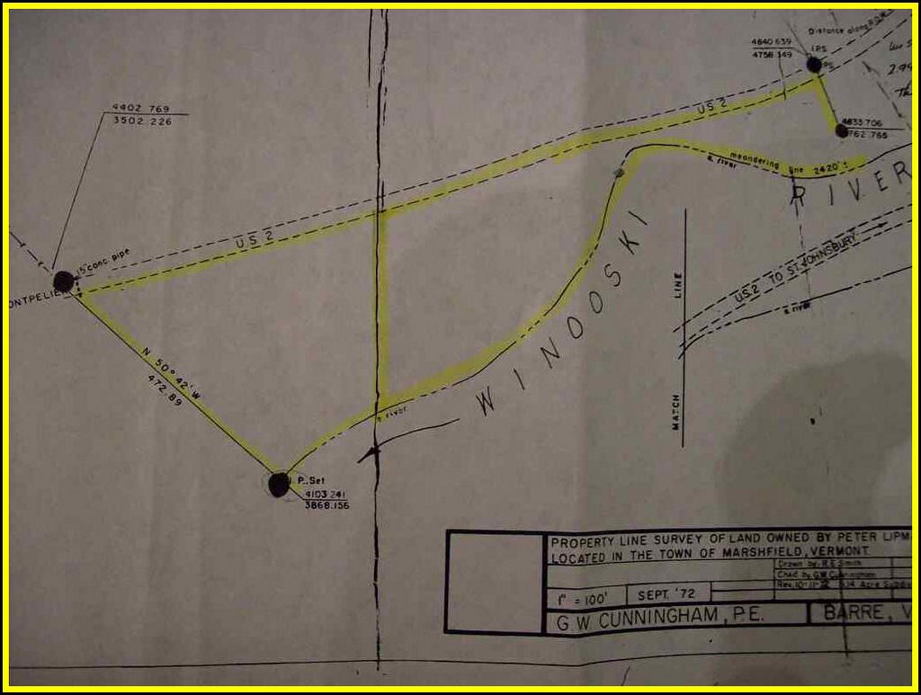
The land had been surveyed and recorded in 1972 but some of the lines had been disrupted and trees that had served as markers had died and rotted into nonexistence. When the highway guys replaced an aging culvert on the west end, they dug up one marker and replaced it with new road and no marker. As Route 2 was raised and replaced over the years, other markers became obscured. A new survey seemed appropriate.
This may seem like a formidable list of items needing attention but it's calm compared to many business plans. There's no pressure for us to open next season and no other burdens beyond what we have committed to so far. The point of detailing this process is the reflection that a business plan is a "must", contingencies have to be realistic and the best of plans will still go off track somewhere.
The map pictured above is the 1972 version we went by to make our purchase. We confirmed the approximate location of two missing markers, identified three pins and a marked tree and then asked for a computer analysis of the approximate acreage. When that exceeded the listed estimate, we proceeded with the purchase. If you are considering a nursery or any other business, follow these examples.
Writing from the mountain above Peacham Pond, where a good business plan makes sense for any business.
George Africa
http://vermontflowerfarm.com
http://thevermontgardener.blogspot.com


